Bertrichamps

Bertrichamps
Bertrichamps (Frankreich)
Staat Frankreich
Region Grand Est
Département (Nr.) Meurthe-et-Moselle (54)
Arrondissement Lunéville
Kanton Baccarat
Gemeindeverband Territoire de Lunéville à Baccarat
Koordinaten 48° 26′ N, 6° 48′ O48.436.7947222222222Koordinaten: 48° 26′ N, 6° 48′ O
Höhe 266–422 m
Fläche 19,66 km²
Einwohner 1.076 (1. Januar 2021)
Bevölkerungsdichte 55 Einw./km²
Postleitzahl 54120
INSEE-Code 54065

Rathaus (Mairie) von Bertrichamps

Vorlage:Infobox Gemeinde in Frankreich/Wartung/abweichendes Wappen in Wikidata

Bertrichamps ist eine französische Gemeinde mit 1.076 Einwohnern (Stand: 1. Januar 2021) im Département Meurthe-et-Moselle in der Region Grand Est (vor 2016 Lothringen). Die Gemeinde gehört zum Arrondissement Lunéville und zum Kanton Baccarat. Die Einwohner werden Bertrichampois genannt.

Geographie

Bertrichamps liegt zwischen Lunéville und Saint-Dié am Fuß der Vogesen. Die Meurthe begrenzt die Gemeinde im Südwesten. Umgeben wird Bertrichamps von den Nachbargemeinden Merviller und Veney im Norden, Neufmaisons im Osten, Raon-l’Étape im Osten und Südosten, Thiaville-sur-Meurthe im Süden, Lachapelle im Südwesten sowie Baccarat im Westen und Nordwesten.

Durch die Gemeinde führt die Route nationale 59.

Bevölkerungsentwicklung

Jahr 1962 1968 1975 1982 1990 1999 2006 2019
Einwohner 824 831 908 1016 1045 1062 1079 1095
Quellen: Cassini und INSEE

Sehenswürdigkeiten

  • Kirche Saint-Jean-Baptiste aus dem 18. Jahrhundert
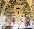
  • Kapelle Saint-Jean aus dem 13. Jahrhundert
Kirche Saint-Jean-Baptiste
  • Kapelle Saint-Jean
Commons: Bertrichamps – Sammlung von Bildern, Videos und Audiodateien

Amenoncourt | Ancerviller | Angomont | Anthelupt | Arracourt | Athienville | Autrepierre | Avricourt | Azerailles | Baccarat | Badonviller | Barbas | Barbonville | Bathelémont | Bauzemont | Bayon | Bénaménil | Bertrambois | Bertrichamps | Bezange-la-Grande | Bienville-la-Petite | Bionville | Blainville-sur-l’Eau | Blâmont | Blémerey | Bonviller | Borville | Bréménil | Brémoncourt | Brouville | Bures | Buriville | Chanteheux | Charmois | Chazelles-sur-Albe | Chenevières | Cirey-sur-Vezouze | Clayeures | Coincourt | Courbesseaux | Crévéchamps | Crion | Croismare | Damelevières | Deneuvre | Deuxville | Domèvre-sur-Vezouze | Domjevin | Domptail-en-l’Air | Drouville | Einvaux | Einville-au-Jard | Emberménil | Essey-la-Côte | Fenneviller | Flainval | Flin | Fontenoy-la-Joûte | Fraimbois | Franconville | Fréménil | Frémonville | Froville | Gélacourt | Gerbéviller | Giriviller | Glonville | Gogney | Gondrexon | Hablainville | Haigneville | Halloville | Harbouey | Haudonville | Haussonville | Hénaménil | Herbéviller | Hériménil | Hoéville | Igney | Jolivet | Juvrecourt | Lachapelle | Lamath | Landécourt | Laneuveville-aux-Bois | Laronxe | Leintrey | Lorey | Loromontzey | Lunéville | Magnières | Maixe | Manonviller | Marainviller | Mattexey | Méhoncourt | Merviller | Mignéville | Moncel-lès-Lunéville | Montigny | Montreux | Mont-sur-Meurthe | Moriviller | Mouacourt | Moyen | Neufmaisons | Neuviller-lès-Badonviller | Nonhigny | Ogéviller | Parroy | Parux | Petitmont | Pettonville | Pexonne | Pierre-Percée | Raon-lès-Leau | Raville-sur-Sânon | Réchicourt-la-Petite | Réclonville | Rehainviller | Reherrey | Reillon | Remenoville | Remoncourt | Repaix | Romain | Rozelieures | Saint-Boingt | Saint-Clément | Sainte-Pôle | Saint-Germain | Saint-Mard | Saint-Martin | Saint-Maurice-aux-Forges | Saint-Rémy-aux-Bois | Saint-Sauveur | Seranville | Serres | Sionviller | Tanconville | Thiaville-sur-Meurthe | Thiébauménil | Vacqueville | Val-et-Châtillon | Valhey | Vallois | Vathiménil | Vaucourt | Vaxainville | Vého | Velle-sur-Moselle | Veney | Vennezey | Verdenal | Vigneulles | Villacourt | Virecourt | Vitrimont | Xermaménil | Xousse | Xures

Normdaten (Geografikum): GND: 1034441442 (lobid, OGND, AKS) | VIAF: 299762874