Újiráz
You can help expand this article with text translated from the corresponding article in Hungarian. (August 2018) Click [show] for important translation instructions.
- View a machine-translated version of the Hungarian article.
- Machine translation, like DeepL or Google Translate, is a useful starting point for translations, but translators must revise errors as necessary and confirm that the translation is accurate, rather than simply copy-pasting machine-translated text into the English Wikipedia.
- Do not translate text that appears unreliable or low-quality. If possible, verify the text with references provided in the foreign-language article.
- You must provide copyright attribution in the edit summary accompanying your translation by providing an interlanguage link to the source of your translation. A model attribution edit summary is
Content in this edit is translated from the existing Hungarian Wikipedia article at [[:hu:Újiráz]]; see its history for attribution. - You may also add the template
{{Translated|hu|Újiráz}}to the talk page. - For more guidance, see Wikipedia:Translation.
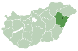
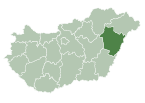
Place in Hajdú-Bihar, Hungary
Újiráz | |
|---|---|
 | |
| Country |  Hungary Hungary |
| County | Hajdú-Bihar |
| District | Berettyóújfalu |
| Area | |
| • Total | 15.47 km2 (5.97 sq mi) |
| Population (2003) | |
| • Total | 576 |
| • Density | 37.23/km2 (96.4/sq mi) |
| Time zone | UTC+1 (CET) |
| • Summer (DST) | UTC+2 (CEST) |
| Postal code | 4146 |
| Area code | 54 |
Újiráz is a village in Berettyóújfalu District of Hajdú-Bihar County, in the Northern Great Plain region of eastern Hungary.
Geography
It covers an area of 15.47 km2 (6 sq mi) and has a population of 576 people (2003).[1]
References
- ^ "Magyarország helységnévtára". www.ksh.hu. Retrieved 2021-03-19.
- v
- t
- e
- Debrecen (county seat)
- Álmosd
- Ártánd
- Bakonszeg
- Báránd
- Bedő
- Berekböszörmény
- Bihardancsháza
- Biharnagybajom
- Bihartorda
- Bocskaikert
- Bojt
- Darvas
- Ebes
- Esztár
- Folyás
- Fülöp
- Furta
- Gáborján
- Görbeháza
- Hajdúbagos
- Hajdúszovát
- Hencida
- Hortobágy
- Kismarja
- Kokad
- Konyár
- Körösszakál
- Körösszegapáti
- Magyarhomorog
- Mezőpeterd
- Mezősas
- Mikepércs
- Monostorpályi
- Nagyhegyes
- Nagykereki
- Nyíracsád
- Nyírmártonfalva
- Sáp
- Sáránd
- Szentpéterszeg
- Szerep
- Tépe
- Tetétlen
- Tiszagyulaháza
- Told
- Újiráz
- Újléta
- Újszentmargita
- Újtikos
- Váncsod
- Vekerd
- History
- Geography
- Government
- Economy
- Culture
- Tourism
46°59′N 21°22′E / 46.983°N 21.367°E / 46.983; 21.367
 | This Hajdú-Bihar location article is a stub. You can help Wikipedia by expanding it. |
- v
- t
- e


