2 Market Place
Building in Poulton-le-Fylde, Lancashire, England
53°50′49″N 2°59′32″W / 53.846945°N 2.992272°W / 53.846945; -2.992272
Listed Building – Grade II


1 Vicarage Road
Location in Wyre Borough
Show map of the Borough of Wyre
1 Vicarage Road
Location in Lancashire
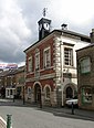
Show map of Lancashire2 Market Place is a Grade II listed building in the English market town of Poulton-le-Fylde, Lancashire. Built in the late 17th or early 18th century, it stands immediately to the south of St Chad's Church, itself Grade II* listed and dating to the 17th century, in the northeastern corner of Market Place.[1] It was formerly a custom house, later a residence.[2]
It is constructed of rendered brick with a slate roof. It is built on two storeys and originally had three bays. In the loft there is visible heavy timber framing including a roof truss between the second and third bays. The building now functions as a shop.[1]
The building's southern facade forms part of the entrance to the narrow The Mews alley of shops and businesses which connects to Chapel Street.
-
 The western gable end of the building is in view to the right of St Chad's gates in this 2008 view

See also
References
- ^ a b "2, Market Place", Heritage Gateway, archived from the original on 29 September 2012, retrieved 16 April 2011
- ^ "2, MARKET PLACE, Non Civil Parish - 1204609 | Historic England". historicengland.org.uk. Retrieved 10 February 2023.
- v
- t
- e
Buildings and structures in the Borough of Wyre
| Places of worship |
|
|---|


| |
| Places of worship |
|
|---|---|
| |
| Places of worship |
|
|---|---|
| Places of worship | |
|---|---|
demolished
- Barnacre-with-Bonds
- Bleasdale
- Cabus
- Catterall
- Claughton
- Fleetwood
- Forton
- Garstang
- Great Eccleston
- Hambleton
- Inskip-with-Sowerby
- Kirkland
- Myerscough & Bilsborrow
- Nateby
- Nether Wyresdale
- Out Rawcliffe
- Pilling
- Poulton-le-Fylde
- Preesall
- Stalmine-with-Staynall
- Thornton-Cleveleys
- Upper Rawcliffe-with-Tarnacre
- Winmarleigh


