Hưng Yên
You can help expand this article with text translated from the corresponding article in Vietnamese. (October 2023) Click [show] for important translation instructions.
- Machine translation, like DeepL or Google Translate, is a useful starting point for translations, but translators must revise errors as necessary and confirm that the translation is accurate, rather than simply copy-pasting machine-translated text into the English Wikipedia.
- Do not translate text that appears unreliable or low-quality. If possible, verify the text with references provided in the foreign-language article.
- You must provide copyright attribution in the edit summary accompanying your translation by providing an interlanguage link to the source of your translation. A model attribution edit summary is
Content in this edit is translated from the existing Vietnamese Wikipedia article at [[:vi:Hưng Yên (thành phố)]]; see its history for attribution. - You may also add the template
{{Translated|vi|Hưng Yên (thành phố)}}to the talk page. - For more guidance, see Wikipedia:Translation.
City in Vietnam
Hưng Yên Thành phố Hưng Yên | |
|---|---|
City (Class-3) | |
| Hưng Yên City | |
 | |
| Seal | |
| Nickname: Phố Hiến | |
 | |
| 20°39′N 106°04′E / 20.650°N 106.067°E / 20.650; 106.067 | |
| Country |  Vietnam Vietnam |
| Province | Hưng Yên |
| Government | |
| • Chairman of People's Committee | Đỗ Xuân Tuyên |
| Area | |
| • Total | 73.4207 km2 (28.3479 sq mi) |
| Population (2013) | |
| • Total | 147,275 |
| • Density | 2,005.9/km2 (5,195/sq mi) |
| Time zone | UTC+7 (Indochina Time) |
| Climate | Cwa |
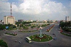
Hưng Yên (listenⓘ) is a city in Vietnam. It is the provincial capital of Hưng Yên Province and is a third-graded city according to Vietnam's city classification table.
Geography
- Hưng Yên is a delta city. It is located in the south of Hưng Yên Province, on the left bank (north bank) of the Red River in the northern part of Vietnam. Hưng Yên is about 60 km away from Hanoi.
- Hưng Yên borders Kim Động District to the north and Tiên Lữ District to the east. The Red River is the natural boundary between Hưng Yên and Hà Nam Province's Lý Nhân District and Duy Tiên District.
- Area: 46.80 km2 (4,685.51 ha)
Demography
- Population: 121,486 people (2008)
Administration
Hưng Yên administers 12 administrative divisions:
- 7 wards (phường): Lê Lợi, Quang Trung, Minh Khai, Hiến Nam, Lam Sơn, Hồng Châu and An Tảo.
- 5 communes (xã): Bảo Khê, Trung Nghĩa, Liên Phương, Hồng Nam and Quảng Châu.
Tourism
The city is well-known in the world (especially among historians) for Phố Hiến (an ancient port-city located in the area). There are still a lot of ancient Asian temples, pagodas and other religious buildings here.
Nhãn lồng (caged longan - a kind of fruit) is one of Hưng Yên's specialties.
Climate
| Climate data for Hưng Yên | |||||||||||||
|---|---|---|---|---|---|---|---|---|---|---|---|---|---|
| Month | Jan | Feb | Mar | Apr | May | Jun | Jul | Aug | Sep | Oct | Nov | Dec | Year |
| Record high °C (°F) | 32.0 (89.6) | 33.6 (92.5) | 37.6 (99.7) | 41.2 (106.2) | 39.4 (102.9) | 40.5 (104.9) | 40.5 (104.9) | 38.4 (101.1) | 36.4 (97.5) | 36.4 (97.5) | 34.5 (94.1) | 31.8 (89.2) | 41.2 (106.2) |
| Mean daily maximum °C (°F) | 19.5 (67.1) | 20.1 (68.2) | 22.6 (72.7) | 27.0 (80.6) | 31.1 (88.0) | 32.8 (91.0) | 32.8 (91.0) | 31.9 (89.4) | 30.8 (87.4) | 28.7 (83.7) | 25.4 (77.7) | 21.7 (71.1) | 27.0 (80.6) |
| Daily mean °C (°F) | 16.2 (61.2) | 17.3 (63.1) | 19.9 (67.8) | 23.7 (74.7) | 27.1 (80.8) | 28.9 (84.0) | 29.1 (84.4) | 28.4 (83.1) | 27.2 (81.0) | 24.8 (76.6) | 21.4 (70.5) | 17.9 (64.2) | 23.5 (74.3) |
| Mean daily minimum °C (°F) | 14.0 (57.2) | 15.4 (59.7) | 18.0 (64.4) | 21.6 (70.9) | 24.4 (75.9) | 26.1 (79.0) | 26.5 (79.7) | 25.9 (78.6) | 24.8 (76.6) | 22.2 (72.0) | 18.7 (65.7) | 15.2 (59.4) | 21.1 (70.0) |
| Record low °C (°F) | 4.9 (40.8) | 5.3 (41.5) | 6.6 (43.9) | 12.2 (54.0) | 16.5 (61.7) | 19.4 (66.9) | 20.6 (69.1) | 21.8 (71.2) | 16.5 (61.7) | 12.5 (54.5) | 8.4 (47.1) | 4.8 (40.6) | 4.8 (40.6) |
| Average rainfall mm (inches) | 27.1 (1.07) | 25.1 (0.99) | 46.8 (1.84) | 86.4 (3.40) | 174.1 (6.85) | 206.2 (8.12) | 220.2 (8.67) | 277.1 (10.91) | 252.5 (9.94) | 169.2 (6.66) | 71.7 (2.82) | 23.6 (0.93) | 1,580.7 (62.23) |
| Average rainy days | 9.1 | 12.4 | 16.6 | 13.2 | 13.1 | 13.8 | 13.8 | 15.7 | 13.6 | 10.7 | 7.2 | 5.6 | 145.0 |
| Average relative humidity (%) | 84.3 | 87.1 | 89.2 | 89.1 | 85.6 | 83.1 | 83.8 | 86.7 | 86.2 | 83.7 | 82.2 | 81.5 | 85.2 |
| Mean monthly sunshine hours | 69.1 | 41.4 | 44.4 | 88.9 | 178.3 | 174.0 | 192.4 | 168.0 | 166.1 | 155.5 | 131.4 | 112.2 | 1,521.8 |
| Source: Vietnam Institute for Building Science and Technology[1] | |||||||||||||
See also
References
- ^ "Vietnam Institute for Building Science and Technology" (PDF).
20°39′N 106°04′E / 20.650°N 106.067°E / 20.650; 106.067
- v
- t
- e
Cities in Vietnam
| Special |
|
|---|---|
| Class-1 |
| Class-1 |
|---|
| Class-1 | |
|---|---|
| Class-2 | |
| Class-3 |
|
Districts of the Red River Delta | ||
|---|---|---|
| Hanoi city |
|  |
| Haiphong city | ||
| Bắc Ninh province | ||
| Hà Nam province | ||
| Hải Dương province |
| |
| Hưng Yên province | ||
| Nam Định province | ||
| Ninh Bình province | ||
| Thái Bình province | ||
| Vĩnh Phúc province |
| |
※ denotes provincial seat. | ||


