McMillin Bridge
Bridge in Pierce County, Washington
47°07′47″N 122°14′09″W / 47.1297227°N 122.2359037°W / 47.1297227; -122.2359037 (McMillin Bridge) SR 162 (until 2015)
McMillin Bridge
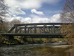

The McMillin Bridge (also known as the Puyallup River Bridge[2]) is a concrete half-through truss bridge crossing the Puyallup River, in Pierce County, Washington, built in 1934.
The main span of the bridge is 170 feet (52 m) long, which was the longest beam span or concrete truss in the US when it was built. It was part of State Route 162 until it was replaced by a new span in 2015.
Design
The bridge design uses a hollow-box system, which was suggested to the design company of W. H. Witt Company by Homer M. Hadley.
The bridge was then built by Dolph Jones.
The bridge was built to replace a steel span that had been washed out by the flooding river in 1933.
Because of economic conditions, the concrete design was chosen over a steel design, with a savings of $826, in addition to lower maintenance costs.
The bridge is unusual in that it combines concrete with the half-through truss design, which was usually built with steel.[3]
Construction
The previous bridge was damaged in 1933, but the replacement bridge was ready to open in 1934, despite the Great Depression.
Historic preservation
The bridge was added to the National Register of Historic Places in 1982. It was saved from demolition after its replacement by a new bridge carrying State Route 162, which opened in 2015.[4]
See also
- List of bridges on the National Register of Historic Places in Washington (state)
- List of bridges documented by the Historic American Engineering Record in Washington (state)
References
- ^ "National Register Information System". National Register of Historic Places. National Park Service. January 23, 2007.
- ^ "Historic Bridges". Retrieved February 20, 2008.
- ^ Holstine & Hobbs 2005, pp. 205–206
- ^ Drysdale, Bruce (September 20, 2015). "SR 162 bridge near Orting opens ahead of schedule". The News Tribune. Retrieved July 9, 2021.
Sources
- Holstine, Craig; Hobbs, Richard (2005). Spanning Washington: Historic Highway Bridges of the Evergreen State. Washington State University Press. ISBN 0-87422-281-8.
External links
- Historic American Engineering Record (HAER) No. WA-73, "McMillin Bridge, Spanning Puyallup River at State Route 162, McMillin, Pierce County, WA", 16 photos, 3 measured drawings, 24 data pages, 1 photo caption page
- v
- t
- e
- List of U.S. National Historic Landmarks by state:
- Alabama
- Alaska
- Arizona
- Arkansas
- California
- Colorado
- Connecticut
- Delaware
- Florida
- Georgia
- Hawaii
- Idaho
- Illinois
- Indiana
- Iowa
- Kansas
- Kentucky
- Louisiana
- Maine
- Maryland
- Massachusetts
- Michigan
- Minnesota
- Mississippi
- Missouri
- Montana
- Nebraska
- Nevada
- New Hampshire
- New Jersey
- New Mexico
- New York
- North Carolina
- North Dakota
- Ohio
- Oklahoma
- Oregon
- Pennsylvania
- Rhode Island
- South Carolina
- South Dakota
- Tennessee
- Texas
- Utah
- Vermont
- Virginia
- Washington
- West Virginia
- Wisconsin
- Wyoming
 National Register of Historic Places portal
 Category


| Authority control databases: Geographic |
|
|---|
 | This article about a property in Washington on the National Register of Historic Places is a stub. You can help Wikipedia by expanding it. |
- v
- t
- e
 | This article about a bridge in the U.S. state of Washington is a stub. You can help Wikipedia by expanding it. |
- v
- t
- e


