Mossoró
Municipality in Northeast, Brazil

Flag

Seal
"Capital do Oeste" ("The Capital of the West") and "Cidade do Sal e do Petróleo" ("City of Salt and Petroleum")
Mossoró da gente. Fazendo nossa vida melhorar. (Our Mossoró. Improving our lives.)

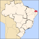
Location in the Rio Grande do Norte

Location of State of Rio Grande do Norte in Brazil
Mossoró (Portuguese pronunciation: [mosoˈɾɔ]) is the second most populous city[2] in the state of Rio Grande do Norte, Brazil, and also the largest municipality of that state. It is equidistant (four hours' drive) from Natal (approximately 277 km or 172 miles), the state capital of Rio Grande do Norte, and from Fortaleza (approximately 260 km or 161.5 miles), the capital of the state of Ceará. It is also in the heart of Brazil's salt production area. Situated in the Oeste Potiguar mesoregion, Mossoró is the country's largest land-based petroleum producer.[3]
History
To Brazilians, the main historical distinctions of the city are the driving off an attack by Lampião and his gang of "social bandits" (see Cangaço) that plundered entire towns in the sertão during the 1920s and 1930s; and also the fact that the city freed its slaves five years before the Lei Áurea abolished slavery in the rest of the country in 1888. Mossoró was also the first city to give women the right to vote in Brazil (Professor Celina Guimarães Viana cast the first vote in 1928), sparking a movement among other cities and states in Brazil that culminated in the official recognition of women's suffrage by the national government in 1934.
Geography
Climate
Mossoró is one of the hottest cities in all of Brazil. It has semi-arid climate with a temperature range of mean lows around 22.7 °C (72.9 °F) and mean highs around 33.4 °C (92.1 °F) throughout the year.[4] However, it is not uncommon for temperatures to exceed 35 °C (95 °F) throughout the year, with temperatures approaching 45 °C (113 °F) unexceptional. The sultriest temperatures are registered from October to January.
A fairly short wet season spans from January to May, while the scorching dry season spans the remainder of the year.
| Climate data for Mossoró | |||||||||||||
|---|---|---|---|---|---|---|---|---|---|---|---|---|---|
| Month | Jan | Feb | Mar | Apr | May | Jun | Jul | Aug | Sep | Oct | Nov | Dec | Year |
| Mean daily maximum °C (°F) | 34.1 (93.4) | 33.3 (91.9) | 32.6 (90.7) | 32.3 (90.1) | 32.3 (90.1) | 32.3 (90.1) | 32.5 (90.5) | 33.8 (92.8) | 34.4 (93.9) | 34.6 (94.3) | 34.6 (94.3) | 34.4 (93.9) | 33.4 (92.1) |
| Daily mean °C (°F) | 26.8 (80.2) | 25 (77) | 27.3 (81.1) | 27.3 (81.1) | 27 (81) | 26.7 (80.1) | 26.5 (79.7) | 27.1 (80.8) | 27.7 (81.9) | 28.1 (82.6) | 28.3 (82.9) | 28.7 (83.7) | 27.2 (81.0) |
| Mean daily minimum °C (°F) | 23.7 (74.7) | 23.5 (74.3) | 23.3 (73.9) | 23.2 (73.8) | 22.8 (73.0) | 21.9 (71.4) | 21.6 (70.9) | 21.3 (70.3) | 21.9 (71.4) | 22.8 (73.0) | 23.2 (73.8) | 23.6 (74.5) | 22.7 (72.9) |
| Average rainfall mm (inches) | 69.3 (2.73) | 130.1 (5.12) | 169.2 (6.66) | 179.6 (7.07) | 109.5 (4.31) | 49.4 (1.94) | 39.9 (1.57) | 11.1 (0.44) | 5.9 (0.23) | 3.4 (0.13) | 3.2 (0.13) | 17.3 (0.68) | 787.9 (31.02) |
| Average relative humidity (%) | 67 | 72 | 78 | 74 | 76 | 72 | 69 | 62 | 61 | 62 | 63 | 66 | 68.5 |
| Mean monthly sunshine hours | 231.7 | 194.4 | 186.4 | 190.3 | 217.1 | 211.3 | 228.3 | 269.1 | 271.7 | 290.3 | 281 | 256.5 | 2,828.1 |
| Source 1: Climate Charts (daily means and humidity);[4] | |||||||||||||
| Source 2: Brazilian National Institute of Meteorology - INMET (rainfall and sun: 1961-1990).[5][6] | |||||||||||||
Climate
| Climate data for Mossoró (1981–2010) | |||||||||||||
|---|---|---|---|---|---|---|---|---|---|---|---|---|---|
| Month | Jan | Feb | Mar | Apr | May | Jun | Jul | Aug | Sep | Oct | Nov | Dec | Year |
| Mean daily maximum °C (°F) | 34.1 (93.4) | 33.9 (93.0) | 33.1 (91.6) | 32.6 (90.7) | 32.6 (90.7) | 32.5 (90.5) | 33.1 (91.6) | 34.3 (93.7) | 35.0 (95.0) | 35.1 (95.2) | 34.9 (94.8) | 34.8 (94.6) | 33.8 (92.8) |
| Daily mean °C (°F) | 28.5 (83.3) | 28.2 (82.8) | 27.6 (81.7) | 27.4 (81.3) | 27.2 (81.0) | 26.9 (80.4) | 27.0 (80.6) | 27.7 (81.9) | 28.3 (82.9) | 28.7 (83.7) | 28.7 (83.7) | 29.0 (84.2) | 27.9 (82.2) |
| Mean daily minimum °C (°F) | 24.4 (75.9) | 24.0 (75.2) | 23.6 (74.5) | 23.5 (74.3) | 23.1 (73.6) | 22.0 (71.6) | 21.6 (70.9) | 21.7 (71.1) | 22.6 (72.7) | 23.5 (74.3) | 23.7 (74.7) | 24.2 (75.6) | 23.2 (73.8) |
| Average precipitation mm (inches) | 95.5 (3.76) | 98.5 (3.88) | 221.3 (8.71) | 202.4 (7.97) | 101.1 (3.98) | 52.7 (2.07) | 36.5 (1.44) | 7.2 (0.28) | 1.8 (0.07) | 2.4 (0.09) | 1.7 (0.07) | 14.3 (0.56) | 835.4 (32.89) |
| Average precipitation days (≥ 1.0 mm) | 7 | 8 | 15 | 14 | 10 | 6 | 4 | 2 | 0 | 0 | 0 | 2 | 68 |
| Average relative humidity (%) | 71.5 | 72.7 | 78.6 | 81.4 | 77.3 | 72.9 | 66.7 | 61.7 | 60.1 | 61.7 | 64.5 | 65.1 | 69.5 |
| Mean monthly sunshine hours | 233.9 | 204.5 | 215.4 | 205.5 | 227.1 | 215.9 | 242.1 | 276.3 | 289.5 | 305.6 | 293.8 | 274.3 | 2,983.9 |
| Source: Instituto Nacional de Meteorologia[7] | |||||||||||||
Demographics
|
|
(96th largest municipality in Brazil).
Culture and recreation

Although it does not have beaches within its city limits, there are several beaches in the surrounding area of the Costa Branca Pole such as the desert beaches of the city of Areia Branca. Canoa Quebrada beach is a short drive away in the neighboring state of Ceará.
The Resistance Museum tells the story of the city and the city's native sons. However, the most famous attraction is the Mossoró Cidade Junina (Mossoró Junina City Festival), a winter festival (festa junina) that attracts more than a million people during the month of June.
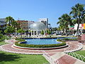
The city has a historic town. Main attractions include the Museu Municipal Jornalista Lauro da Escóssia (Journalist Lauro da Escóssia Municipal Museum), also known as the Cangaço Museum, the Station Arts old railway station museum, the Oil Museum, St. Vincent Church, and the Cathedral of Santa Luzia. Other attractions include the Palace of Resistance, former residence of mayor Rodolfo Fernandes, who was the leader of the resistance against Lampião's bandits and served as a rampart against attacks from them. There is also the Bode Market, an ovine and caprine trading center where traders and buyers of sheep and goats continue the long-held rural traditions of the northeast, as well as the Central Market and the Railway Bridge.
In September, the city stages the Auto Da Liberdade (The Procession of Liberty) with an all-paid cast of 2,000 and a 600-member chorus as part of its Festa da Liberdade (Brazilian independence celebrations).
Mossoró also has a shopping center, Mossoró West Shopping.
Mossoró is also home to the Hotel Thermas Resort which is the largest thermal water park in Brazil. The heated water used in the resort arises from a zone of geothermal hot springs located in the vicinity of the city. The city is the seat of the Roman Catholic Diocese of Mossoró.[8][9]
-
 Canoa Quebrada Beach
 -
 Ponta do Mel, Areia Branca
 -
 Mossoró Old City Hall
 -
 Rodolfo Fernandes Square


Education
Colleges and Universities
The Federal University of the Semi-Arid is located in Mossoró.
The following have campuses in the city:
- Faculdade de Ciências e Tecnologia Mater Christi
- Faculdade de Enfermagem Nova Esperança de Mossoró - FACENE/RN
- Universidade do Estado do Rio Grande do Norte
Grade schools and high schools
You can see a listing of public and private elementary, junior, and senior high schools in Mossoró HERE (In Portuguese.) UNP universidade Potiguar
Regional transportation

Airports
Mossoró is served by the following airports:
- Mossoró Airport (Dix-Sept Rosado Airport) - 2.7 km away
- Aeroporto Internacional de Fortaleza (Pinto Martins International Airport) - 205.2 km away
- Aeroporto Internacional da Grande Natal or Greater Natal International Airport (Opened to replace the old airport, the only airport that handles civil aviation in the area).
Highways
- BR-304
- BR-110
- BR-405
- BR-437
Distances to other Brazilian cities
- São Paulo: 2,274 km (1,413 mi)
- Rio de Janeiro: 2,070 km (1,290 mi)
- Brasília: 1,652 km (1,027 mi)
- Salvador: 876 km (544 mi)
- Belo Horizonte: 1,779 km (1,105 mi)
- Curitiba: 2,588 km (1,608 mi)
- Porto Alegre: 3,126 km (1,942 mi)
- Manaus: 2,529 km (1,571 mi)
Images
-
 Memorial da Resistência (Resistance Memorial)
 -
 Mossoró Cidade Junina (Mossoró City Junina Festival)
 -
 Petroleum Extraction
 -
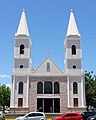 Cathedral of Santa Luzia
 - Mossoró, 1956. National Archives of Brazil.


See also
 South America portal
 Brazil portal


- List of cities
- List of major cities in Brazil
- List of municipalities of Brazil
- Municipalities of Rio Grande do Norte (RN)
References
- ^ IBGE 2020
- ^ "IBGE - Cidades@". Archived from the original on 2010-07-15.
- ^ Workshop. Potiguar anp.gov.br [dead link]
- ^ a b "Mossoro, Brazil: Climate, Global Warming, and Daylight Charts and Data". Climate Charts. Archived from the original on June 5, 2014. Retrieved September 8, 2014.
- ^ "Precipitação Acumulada Mensal e Anual (mm)" (in Portuguese). Brazilian National Institute of Meteorology. 1961–1990. Archived from the original on August 8, 2014. Retrieved September 8, 2014.
- ^ "Insolação Total (horas)". Brazilian National Institute of Meteorology. Archived from the original on August 8, 2014. Retrieved September 8, 2014.
- ^ "Normais Climatológicas Do Brasil 1981–2010" (in Portuguese). Instituto Nacional de Meteorologia. Retrieved 21 May 2024.
- ^ "Mossoró (Diocese) [Catholic-Hierarchy]".
- ^ "Diocese of Mossoró, Brazil". GCatholic. Retrieved 30 June 2023.
External links
Wikimedia Commons has media related to Mossoró.
Wikisource has original text related to this article:
Mossoró
- (in Portuguese) Official Website
- (in Portuguese) Mossoró Cidade Junina Official Site
- (in Portuguese) LFG
- (in Portuguese) Federal University of the Semi-Arid
- (in Portuguese) De Fato Newspaper
- (in Portuguese) Thermas Resort
- v
- t
- e
| Transport | |
|---|---|
| Culture | |
|---|---|
| Religion |
|
| |||||||||||||||
|---|---|---|---|---|---|---|---|---|---|---|---|---|---|---|---|
Capital: Natal | |||||||||||||||
| Mesoregion Agreste Potiguar |
|  | |||||||||||||
| Mesoregion Central Potiguar |
| ||||||||||||||
| Mesoregion Leste Potiguar |
| ||||||||||||||
| Mesoregion Oeste Potiguar |
| ||||||||||||||

Authority control databases | |
|---|---|
| International |
|
| National |
|


