National Register of Historic Places listings in Macon County, Georgia

This is a list of properties and districts in Macon County, Georgia that are listed on the National Register of Historic Places (NRHP).
Map all coordinates using OpenStreetMap
Download coordinates as:
- KML
- GPX (all coordinates)
- GPX (primary coordinates)
- GPX (secondary coordinates)
This National Park Service list is complete through NPS recent listings posted June 7, 2024.[1]
- v
- t
- e
Properties on the National Register of Historic Places in Georgia by county
- Appling
- Atkinson
- Bacon
- Baker
- Baldwin
- Banks
- Barrow
- Bartow
- Ben Hill
- Berrien
- Bibb
- Bleckley
- Brantley
- Brooks
- Bryan
- Bulloch
- Burke
- Butts
- Calhoun
- Camden
- Candler
- Carroll
- Catoosa
- Charlton
- Chatham
- Chattahoochee
- Chattooga
- Cherokee
- Clarke
- Clay
- Clayton
- Clinch
- Cobb
- Coffee
- Colquitt
- Columbia
- Cook
- Coweta
- Crawford
- Crisp
- Dade
- Dawson
- Decatur
- DeKalb
- Dodge
- Dooly
- Dougherty
- Douglas
- Early
- Echols
- Effingham
- Elbert
- Emanuel
- Evans
- Fannin
- Fayette
- Floyd
- Forsyth
- Franklin
- Fulton
- Gilmer
- Glascock
- Glynn
- Gordon
- Grady
- Greene
- Gwinnett
- Habersham
- Hall
- Hancock
- Haralson
- Harris
- Hart
- Heard
- Henry
- Houston
- Irwin
- Jackson
- Jasper
- Jeff Davis
- Jefferson
- Jenkins
- Johnson
- Jones
- Lamar
- Lanier
- Laurens
- Lee
- Liberty
- Lincoln
- Long
- Lowndes
- Lumpkin
- Macon
- Madison
- Marion
- McDuffie
- McIntosh
- Meriwether
- Miller
- Mitchell
- Monroe
- Montgomery
- Morgan
- Murray
- Muscogee
- Newton
- Oconee
- Oglethorpe
- Paulding
- Peach
- Pickens
- Pierce
- Pike
- Polk
- Pulaski
- Putnam
- Quitman
- Rabun
- Randolph
- Richmond
- Rockdale
- Schley
- Screven
- Seminole
- Spalding
- Stephens
- Stewart
- Sumter
- Talbot
- Taliaferro
- Tattnall
- Taylor
- Telfair
- Terrell
- Thomas
- Tift
- Toombs
- Towns
- Treutlen
- Troup
- Turner
- Twiggs
- Union
- Upson
- Walker
- Walton
- Ware
- Warren
- Washington
- Wayne
- Webster
- Wheeler
- White
- Whitfield
- Wilcox
- Wilkes
- Wilkinson
- Worth

Current listings
| [2] | Name on the Register | Image | Date listed[3] | Location | City or town | Description |
|---|---|---|---|---|---|---|
| 1 | Alma Fruit Farm | Upload image | November 25, 1980 (#80004446) | GA 49W 32°26′13″N 84°00′04″W / 32.4369°N 84.0011°W / 32.4369; -84.0011 (Alma Fruit Farm) | Marshallville | Also known as the Jones-Peterson House. |
| 2 | Andersonville National Historic Site |  | October 16, 1970 (#70000070) | 1 mi. E of Andersonville on GA 49 32°11′41″N 84°07′44″W / 32.19469°N 84.12895°W / 32.19469; -84.12895 (Andersonville National Historic Site) | Andersonville | administered by the National Park Service |
| 3 | Billy Place | Upload image | November 25, 1980 (#80004444) | Rt. 1 32°25′10″N 83°57′44″W / 32.419444°N 83.962222°W / 32.419444; -83.962222 (Billy Place) | Marshallville | |
| 4 | DeVaughn-Lewis House | Upload image | May 2, 1985 (#85000937) | 510 S. Dooly St. 32°17′38″N 84°01′53″W / 32.293889°N 84.031389°W / 32.293889; -84.031389 (DeVaughn-Lewis House) | Montezuma | |
| 5 | East Main Street Residential District | Upload image | November 25, 1980 (#80004454) | E. Main St. 32°27′18″N 83°56′12″W / 32.455°N 83.936667°W / 32.455; -83.936667 (East Main Street Residential District) | Marshallville | |
| 6 | William Hamilton Felton House | Upload image | November 25, 1980 (#80004447) | McCaskill St. 32°26′50″N 83°57′02″W / 32.44731°N 83.95050°W / 32.44731; -83.95050 (William Hamilton Felton House) | Marshallville | |
| 7 | Wilkes Knob Plantation | Upload image | November 25, 1980 (#80004451) | Rt. 1 32°28′20″N 83°52′48″W / 32.47217°N 83.87995°W / 32.47217; -83.87995 (Wilkes Knob Plantation) | Marshallville | |
| 8 | Lamson-Richardson School | Upload image | May 18, 1981 (#81000697) | Railroad St. 32°26′49″N 83°56′40″W / 32.446944°N 83.944444°W / 32.446944; -83.944444 (Lamson-Richardson School) | Marshallville | |
| 9 | Macon County Courthouse | 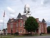 | September 18, 1980 (#80001113) | Courthouse Sq. 32°17′36″N 84°03′36″W / 32.29341°N 84.06001°W / 32.29341; -84.06001 (Macon County Courthouse) | Oglethorpe | |
| 10 | Marshallville Commercial District | Upload image | November 25, 1980 (#80004452) | Main St. 32°27′23″N 83°55′24″W / 32.456389°N 83.923333°W / 32.456389; -83.923333 (Marshallville Commercial District) | Marshallville | |
| 11 | Massee Lane | Upload image | November 25, 1980 (#80004450) | Rt. 1 32°29′17″N 83°56′09″W / 32.48803°N 83.93573°W / 32.48803; -83.93573 (Massee Lane) | Marshallville | |
| 12 | Montezuma Depot |  | June 12, 1980 (#80001112) | S. Dooly St. 32°18′02″N 84°01′46″W / 32.300556°N 84.029444°W / 32.300556; -84.029444 (Montezuma Depot) | Montezuma | |
| 13 | Montezuma Historic District | 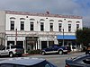 | October 13, 2003 (#03001017) | Roughly centered along N. and S. Dooly St. 32°18′11″N 84°01′47″W / 32.303056°N 84.029722°W / 32.303056; -84.029722 (Montezuma Historic District) | Montezuma | |
| 14 | Thronateeska | Upload image | November 25, 1980 (#80004445) | Rt. 1 32°25′14″N 84°00′59″W / 32.42050°N 84.01642°W / 32.42050; -84.01642 (Thronateeska) | Marshallville | Seems to be gone in recent satellite views |
| 15 | West Main Street Residential District | Upload image | November 25, 1980 (#80004453) | W. Main St. 32°27′21″N 83°56′59″W / 32.455833°N 83.949722°W / 32.455833; -83.949722 (West Main Street Residential District) | Marshallville | |
| 16 | Willow Lake | Upload image | November 25, 1980 (#80004449) | Rt. 1 32°28′36″N 83°53′25″W / 32.47654°N 83.89026°W / 32.47654; -83.89026 (Willow Lake) | Marshallville |
References
- ^ National Park Service, United States Department of the Interior, "National Register of Historic Places: Weekly List Actions", retrieved June 7, 2024.
- ^ Numbers represent an alphabetical ordering by significant words. Various colorings, defined here, differentiate National Historic Landmarks and historic districts from other NRHP buildings, structures, sites or objects.
- ^ The eight-digit number below each date is the number assigned to each location in the National Register Information System database, which can be viewed by clicking the number.
Wikimedia Commons has media related to National Register of Historic Places in Macon County, Georgia.
| |
|---|---|
| Topics | |
| Lists by state |
|
| Lists by insular areas | |
| Lists by associated state | |
| Other areas | |
| Related | |
| |


