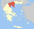
Pella (regional unit)
Regional unit in Greece
Pella Περιφερειακή ενότητα Πέλλας | |
|---|---|
 Municipalities of Pella | |
| 40°55′N 22°05′E / 40.917°N 22.083°E / 40.917; 22.083 | |
| Country | Greece |
| Administrative region | Central Macedonia |
| Seat | Edessa |
| Area | |
| • Total | 2,506 km2 (968 sq mi) |
| Population (2021)[1] | |
| • Total | 126,740 |
| • Density | 51/km2 (130/sq mi) |
| Time zone | UTC+2 (EET) |
| • Summer (DST) | UTC+3 (EEST) |
| Postal code | 58x xx |
| Area code(s) | 238x0 |
| Vehicle registration | ΕΕ |
| Website | www |
Pella (Greek: Περιφερειακή ενότητα Πέλλας) is one of the regional units of Greece, in the geographic region of Macedonia. It is part of the Region of Central Macedonia. It is named after the ancient city of Pella, the capital of ancient Macedonia and the birthplace of Alexander the Great.[2] The capital of Pella is Edessa with a population of 19,036 inhabitants according to the census of 2021, while the largest town is Giannitsa. Other towns include Aridaia, Skydra, Arnissa, Exaplatanos and Krya Vrysi.
Administration
According to the 2011 census the population of the regional unit of Pella was 139,680.[3] It is subdivided into 4 municipalities. These are:[3]
Prefecture


As a part of the 2011 Kallikratis government reform, the regional unit of Pella was created out of the former prefecture Pella (Greek: Νομός Πέλλας). The prefecture had the same territory as the present regional unit. At the same time, the municipalities were reorganised, according to the table below.[3]
| New municipality | Old municipalities | Seat |
|---|---|---|
| Almopia | Aridaia | Aridaia |
| Exaplatanos | ||
| Edessa | Edessa | Edessa |
| Vegoritida | ||
| Pella | Pella | Giannitsa |
| Giannitsa | ||
| Krya Vrysi | ||
| Kyrros | ||
| Megas Alexandros | ||
| Skydra | Skydra | Skydra |
| Meniida |
Provinces
The former prefecture of Pella was subdivided into the following provinces:[4]
| Provinces of Pella Prefecture | Seat (if different) |
|---|---|
| Province of Almopia | Aridaia |
| Province of Edessa | |
| Province of Giannitsa |
Note: Provinces no longer hold any legal status in Greece.
Geography
The regional unit covers an area of 2,505.8 square kilometres (967+1⁄2 sq mi), the majority of which is covered by arable land, forests and pastures. Mountainous areas surrounding Pella are the Voras Mountains (with Kaimaktsalan reaching a height of 2,524 m), Mount Vermion (2,027 m), Mount Paiko (1,458 m), Mount Tzenna (2,182 m) and Mount Pinovo (2,154 m). The main plains are Pozar in the north and the vast plain of Giannitsà in the southeastern part. Other natural features of the area include Lakes Vegoritida and Agra, and Rivers Loudias and Edessian. Pella's southernmost portion is flat and in ancient times, it was a gulf connected to the Aegean Sea. The elevation in the south does not exceed about 5 to 10 m (16 to 33 ft) above sea level. Pella has surface and groundwater resources. There are a number of archaeological sites in the area.
Pella borders the regional units of Kilkis to the northeast, Thessaloniki to the east, Imathia to the south, Kozani to the southwest, by Lake Vegoritida to the southwest, and by Florina to the west. To the north, it is bounded by the national border between Greece and North Macedonia.
History


In antiquity, the area around the modern Pella regional unit was part of the ancient Greek Kingdom of Macedon. It later became part of the Roman Empire and later the Byzantine and the Ottoman Empires. Following approximately 500 years of Ottoman rule, it rejoined Greece in 1913, following the Balkan Wars.
Tourism
- Ancient Pella and Archaeological Museum of Pella: The capital of ancient Macedonia and birthplace of Alexander the Great. A number of archaeological findings are housed in the Palace and the New Museum.[5]
- Loudias River
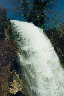
- Waterfalls in the city of Edessa [6]
- Pozar thermal baths: The hot springs are located in a mountainous area (altitude 360–390 m) and occupy an area of 30 hectares (75 acres). Five spa gush along the warm river, which continues to flow in the basin of Almopia.
- Kaimakchalan ski resort: Mount Kaimakchalan or Vorras is the third largest in height mount in Greece (altitude 2,524 m). There is a ski area with 16 ski slopes. At the foot of the mountain there is the village of Agios Athanasios.
- Giannitsa Ottoman monuments: At the city of Giannitsa there are a lot of buildings from the Ottoman period like the Clock Tower, Mausoleum and baths of Gazi Evrenos, House of Emin Bey, The Baths and the mausoleum of Ahmet Bey, Mosque of Sheikh Ilachi, Mosque of Iskender Bey.[7]
Agriculture
The southern part of the regional unit has a number of orchards. While agriculture once represented its main industry, today, manufacturing, services and other businesses dominate about 70% of its industry.
Transport
- GR-1 (old highway), SE
- GR-2/E90, W, SW, Cen., E, SE
- Edessa - Verroia road, S
- Thessaloniki-Giannitsa-Edessa
See also
References
- ^ "Αποτελέσματα Απογραφής Πληθυσμού - Κατοικιών 2021, Μόνιμος Πληθυσμός κατά οικισμό" [Results of the 2021 Population - Housing Census, Permanent population by settlement] (in Greek). Hellenic Statistical Authority. 29 March 2024.
- ^ Law, Gwillim (1999). Administrative subdivisions of countries: a comprehensive world reference, 1900 through 1998. McFarland. p. 152. ISBN 978-0-7864-0729-3.
- ^ a b c "ΦΕΚ A 87/2010, Kallikratis reform law text" (in Greek). Government Gazette.
- ^ "Detailed census results 1991" (PDF). (39 MB) (in Greek and French)
- ^ "Αρχαιολογικό Μουσείο Πέλλας | Αρχαιολογικό Μουσείο Πέλλας - Πέλλα" (in Greek). Pella-museum.gr. 2022-03-31. Retrieved 2022-04-14.
- ^ "Edessa waterfalls - European waterfalls".
- ^ "Giannitsa Clock Tower".
External links
Wikimedia Commons has media related to Pella Regional Unit.
- Official website of the prefecture of Pella
- Tzena - Pinovo - East Voras terrain map by Geopsis
- v
- t
- e
Administrative division of the Central Macedonia Region
- Area
- 18,811 km2 (7,263 sq mi)
- Population
- 1,882,108 (as of 2011)
- Municipalities
- 38 (since 2011)
- Capital
- Thessaloniki
- Aristotelis
- Kassandra
- Nea Propontida
- Polygyros
- Sithonia
- Kilkis
- Paionia
- Amfipoli
- Emmanouil Pappas
- Irakleia
- Nea Zichni
- Serres
- Sintiki
- Visaltia
- Regional governor
- Apostolos Tzitzikostas (since 2013, elected 2014 & 2019)
- Decentralized Administration
- Macedonia and Thrace
Authority control databases | |
|---|---|
| International |
|
| National |
|
| Geographic |
|


