Silverwater Bridge
Bridge in New South Wales, Australia
33°49′27″S 151°03′05″E / 33.8241°S 151.0513083°E / -33.8241; 151.0513083
- Motor vehicles
- Pedestrians
- Bicycles

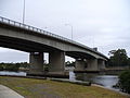
Silverwater Bridge is a concrete box girder bridge[2] that spans the Parramatta River west of the central business district in Sydney, New South Wales, Australia. The bridge carries Silverwater Road (A6) over the river to link Silverwater in the south to Rydalmere and Ermington in the north.
Description
The Silverwater Bridge opened on 10 November 1962,[4] and was the first concrete box girder bridge built in New South Wales.[2][3]
It was the first of the two major bridges needed to construct the Hornsby-Heathcote county road (the other being the Alfords Point Bridge), and was the second project undertaken in the construction of this county road (the first being Olympic Drive Lidcombe, between Boorea and Church Streets, in 1959).
In conjunction with the construction of the bridge, Silverwater Road between Parramatta Road and the bridge was widened to six lanes, and was extended across the new bridge to connect to Victoria Road at Ermington.
The origin of the suburb's name, and subsequently the bridge's name, is unknown. It may have been a reference to the nearby Parramatta River, which could have provided silver reflections of light off the water.[5]
Other crossings over the Parramatta River include the Gladesville Bridge and Ryde Bridge.
Gallery
-
 Silverwater Bridge, looking downriver, in 2007.
 -
 Silverwater Bridge, looking upriver, in 2006.
 -
 Silverwater Bridge at dusk, in 2018


See also
 Transport portal
 Engineering portal
 New South Wales portal
 Australian roads portal


References
- ^ "Average Daily Traffic Volumes" (PDF). NSW Roads & Maritime Services (PDF). Government of New South Wales. 2012. Retrieved 12 January 2015.
- ^ a b c Kass, Terry (February 2006). "RTA Thematic History: A component of the RTA Heritage and Conservation Register" (PDF). NSW Roads & Maritime Services (PDF) (2nd ed.). Government of New South Wales. p. 53. Retrieved 12 January 2015.
- ^ a b RiverCat (9 December 1935). "Parramatta River Bridges" (PDF). Australian Society for History of Engineering and Technology. Retrieved 15 January 2015.
- ^ "Parramatta's history: A timeline" (PDF) (PDF). Parramatta City Council. 2010. Retrieved 12 January 2015.
- ^ Pollen, Frances, ed. (1990). The Book of Sydney Suburbs. Australia: Angus & Robertson Publishers. ISBN 0-207-14495-8.


