Stechlin
Municipality in Brandenburg, Germany
Location of Stechlin within Oberhavel district

(2019–24) Roy Lepschies[1]
(2022-12-31)[2]
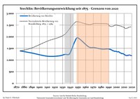
16775
Stechlin is a municipality in the Oberhavel district, in Brandenburg, Germany.
Geography
Stechlin is part of the northern border of Brandenburg, at the start of the Mecklenburg Lake District. It is part of the Stechlin-Ruppiner Land Nature Park, surrounded by the Menzer Forest and has many lakes in the area. The most famous is Lake Stechlin (Stechlinsee) which is a protected area.
Districts of Stechlin
- Dagow
- Dollgow
- Güldenhof
- Menz
- Neuglobsow
- Neuroofen
- Schulzenhof
Demography
|
|
|
District Authority
Stechlin is in the borough of Gransee. Stechlin has its own council that is responsible for 3 districts:
- Dollgow with Schulzenhof and Güldenhof
- Neuglobsow with Dagow
- Menz with Neuroofen
-
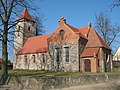 Church in Menz
 -
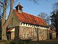 Church in Neuglobsow
 -
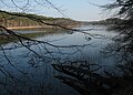 Lake Roofen in Menz
 -
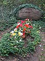 Erwin Strittmatter's grave in Schulzenhof


See also
- Roofensee
References
- ^ Landkreis Oberhavel Wahl der Bürgermeisterin / des Bürgermeisters, accessed 2 July 2021.
- ^ "Bevölkerungsentwicklung und Bevölkerungsstandim Land Brandenburg Dezember 2022" (PDF). Amt für Statistik Berlin-Brandenburg (in German). June 2023.
- ^ Detailed data sources are to be found in the Wikimedia Commons.Population Projection Brandenburg at Wikimedia Commons
- v
- t
- e
Towns and municipalities in Oberhavel

Authority control databases | |
|---|---|
| International |
|
| National |
|
 | This Brandenburg location article is a stub. You can help Wikipedia by expanding it. |
- v
- t
- e


