Tuskar Rock, Ireland
Island in Ireland
Lighthouse
52°12.175′N 6°12.445′W / 52.202917°N 6.207417°W / 52.202917; -6.207417Tuskar Rock (Irish: An Tuscar)[3] is a group of rocks topped by a lighthouse 11 kilometres (6.8 miles) off the southeast coast of County Wexford, Ireland. The rocks have probably destroyed more ships than any other Irish coastal feature.[4][5] One hundred and seventy-six wrecks are listed for the Tuskar Rock area at Irish Wrecks Online.[6]
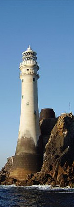
The Tuskar Rock lighthouse, built from granite and standing 120 feet (37 metres) tall, was built over a period of years beginning in 1812. In October of that year, a storm struck, washing away temporary barracks that had been erected on the island, and killing fourteen workmen—the worst such disaster in Ireland's history of lighthouse construction.[7] The surviving workers clung to the island's slippery rocks for two full days before being discovered and rescued.[7] Work resumed, and the lighthouse was completed, entering into operation on 4 June 1815.[7]
The Tuskar Rock air disaster occurred near the rock on 24 March 1968 when Aer Lingus flight 712, en route from Cork to London, crashed into the sea with the loss of all 61 people on board.
The name Tuskar rock has no foundation in the Irish language but actually came from the Vikings. It is one of many Viking place names found in the south of Wexford and means simply large (tu) rock (skar) in Old Norse.[8]
Tuskar lighthouse is mentioned in John Masefield's ballad The Yarn of the Loch Achray as the place where the clipper Loch Achray dropped her tug, before sailing to the South Atlantic where she was wrecked off the River Plate.[citation needed]
Demographics
|
| |||||||||||||||||||||||||||||||||||||||||||||||||||||||||||||||||||||||||||
| Source: Central Statistics Office. "CNA17: Population by Off Shore Island, Sex and Year". irishislands.info. Retrieved 12 October 2016. | ||||||||||||||||||||||||||||||||||||||||||||||||||||||||||||||||||||||||||||
See also
 Ireland portal

- List of islands of Ireland
- List of lighthouses in Ireland
- Coastal landforms of Ireland
- Commissioners of Irish Lights
References
Wikimedia Commons has media related to Tuskar Rock lighthouse.
- ^ Rowlett, Russ. "Lighthouses of Eastern Ireland (Leinster)". The Lighthouse Directory. University of North Carolina at Chapel Hill.
- ^ Tuskar Rock Lighthouse Commissioners of Irish Lights
- ^ Tuskar Rock. Irish Placenames Database. Retrieved: 2010-10-22.
- ^ Tuskar Rock. Commissioners for Irish Lights. Retrieved: 2010-10-22.
- ^ Tuskar Rock Archived 3 February 2007 at the Wayback Machine. Commissioners for Irish Lights, 1997. Retrieved: 2010-10-22.
- ^ Tuskar Rock. irishwrecksonline.net. Retrieved: 2010-10-23.
- ^ a b c Krauskopf, Sharma (2001) Irish Lighthouses; p.15.
- ^ Billy Colfer (2004) The Hook Peninsula: County Wexford p30 Cork University Press ISBN 9781859183786
- v
- t
- e
Lighthouses in Ireland
Lighthouses are shown in anti-clockwise sequence beginning from the north and proceeding west, south, east, and back to north.
- Inishowen
- Inishtrahull
- Fanad
- Dunree
- Buncrana
- Tory Island
- Arranmore
- Ballagh Rocks
- Rathlin O'Birne
- Rotten Island
- St. John's
- Blackrock
- Lower Rosses
- Metal Man
- Oyster Island
- Broad Haven
- Eagle Island
- Blackrock
- Blacksod Bay
- Achillbeg
- Inishgort
- Slyne Head
- Cashla Bay
- Eeragh
- Straw Island
- Inisheer
- Blackhead
- Loop Head
- Kilcredaun Head
- Corlis Point Front
- Corlis Point Rear
- Scattery Island
- Little Samphire Island
- Inishtearaght
- Cromwell Point
- Valentia Rear
- Valentia Front
- Skelligs
- Bull Rock
- Ardnakinna
- Castletown Directional Light
- Roancarrig
- Sheep's Head
- Mizen Head
- Crookhaven
- Copper Point
- Fastnet Rock
- Baltimore Beacon
- Galley Head
- Old Head of Kinsale
- Charlesfort
- Spit Bank
- Roche's Point
- Ballycotton
- Youghal
- Mine Head
- Ballinacourty Point
- Dunmore East
- Green Island
- Vidal Bank
- Haulbowline
- St. John's Point
- Angus Rock
- Donaghadee
- Mew Island
- Blackhead
- Chaine Memorial
- The Maidens
- Rathlin East
- Rue Point
- Rathlin West
- Coastal landforms of Ireland
- Commissioners of Irish Lights
- Lightvessels in Ireland
- List of islands of Ireland
- List of lighthouses in Ireland
- Ireland portal
 Northern Ireland portal

Authority control databases | |
|---|---|
| International |
|
| National |
|
| Tuskar Rock Lighthouse |
|


