District de Changshou

Cet article est une ébauche concernant une localité chinoise.
Vous pouvez partager vos connaissances en l’améliorant (comment ?) selon les recommandations des projets correspondants.
| Chángshòu Qū 长寿区 | |||
 | |||
| Administration | |||
|---|---|---|---|
| Pays |  Chine Chine | ||
| Province ou région autonome | municipalité de Chongqing | ||
| Statut administratif | District | ||
| Code postal | 401220[1] | ||
| Indicatif | +86 (0) | ||
| Démographie | |||
| 874 949 hab. (2004) | |||
| Densité | 615 hab./km2 | ||
| Géographie | |||
| Coordonnées | 29° 57′ 48″ nord, 107° 06′ 47″ est | ||
| Superficie | 142 362 ha = 1 423,62 km2 | ||
| Localisation | |||
 | |||
| Géolocalisation sur la carte : Chine
Géolocalisation sur la carte : Chine
| |||
| Liens | |||
| Site web | wt.cqcs.gov.cn | ||
modifier  | |||


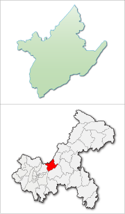
Le district de Changshou (长寿区 ; pinyin : Chángshòu Qū) est une subdivision de la municipalité de Chongqing en Chine.
Géographie
Sa superficie est de 1 423,62 km².
Démographie
La population du district était de 880 838 habitants en 1999[2], et de 874 949 en 2004, pour une densité de 614,55 au km² [3].
Notes et références
- ↑ (en) Codes postaux et téléphoniques de la municipalité de Chongqing, (en) China Zip Code/ Telephone Code, ChinaTravel.
- ↑ (en) National Population Statistics Materials by County and City - 1999 Period, in China County & City Population 1999, Harvard China Historical GIS
- ↑ (zh) Page descriptive (Phoer.net)
Sources
- Géographie : (zh) Page descriptive (Phoer.net)
Voir aussi
Lien externe
- (zh) Site officiel
v · m Subdivisions de niveau district de Chongqing | ||
|---|---|---|
| Districts |  | |
| Xian | ||
| Xian autonomes | ||
 Portail de la Chine


